Euston Area Plan Pedestrian Analysis
Year
2013
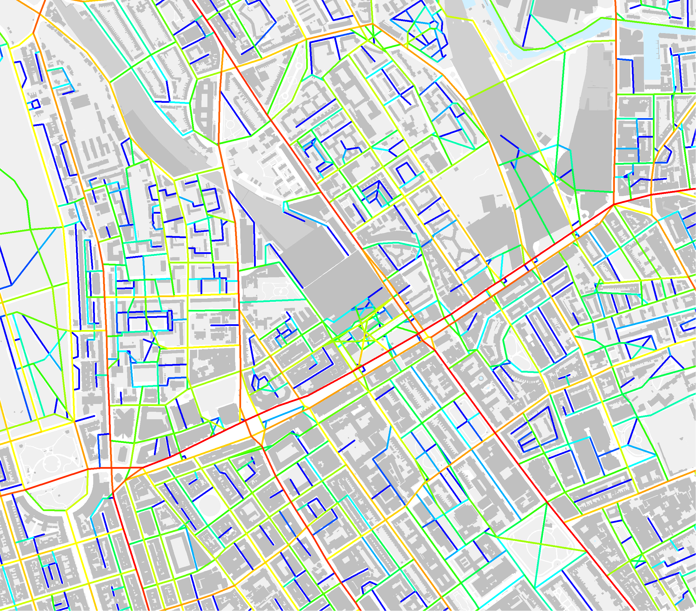
Analysis indicating the high spatial accessibility potential as well as poor east west connectivity to the north of the station.
The opportunity
Euston Station is one of London’s principal termini for rail, underground and bus services. At peak times the station is a busy and congested interchange. The surrounding area is characterised by a mixture of commercial, retail, educational, health and recreational amenities. Access to these amenities in the south of the station is severely hampered by A501 Euston Road. To the north of the station, there is a lack of east-west connectivity due to the rail infrastructure connected to Euston Station.
The Euston area has been identified in the London Plan as a growth area and a key location for regeneration.
London Borough of Camden, the Greater London Authority and Transport for London jointly prepared The Euston Area Plan (EAP) that addresses growth in population and jobs the possible implementation of Euston Station as a portal to High Speed 2. The introduction of HS2 at Euston Station will change the station’s layout and increase the number of passengers coming in and out of the station. Along with passenger growth, a strong increase in cycling from and to the station is also foreseen.
Space Syntax was appointed to carry out an urban baseline analysis, an urban impact assessment and design recommendations with the aim to quantify, predict and compare the impact of different scenarios with and without HS2 on pedestrian and cyclist movement patterns.
Map
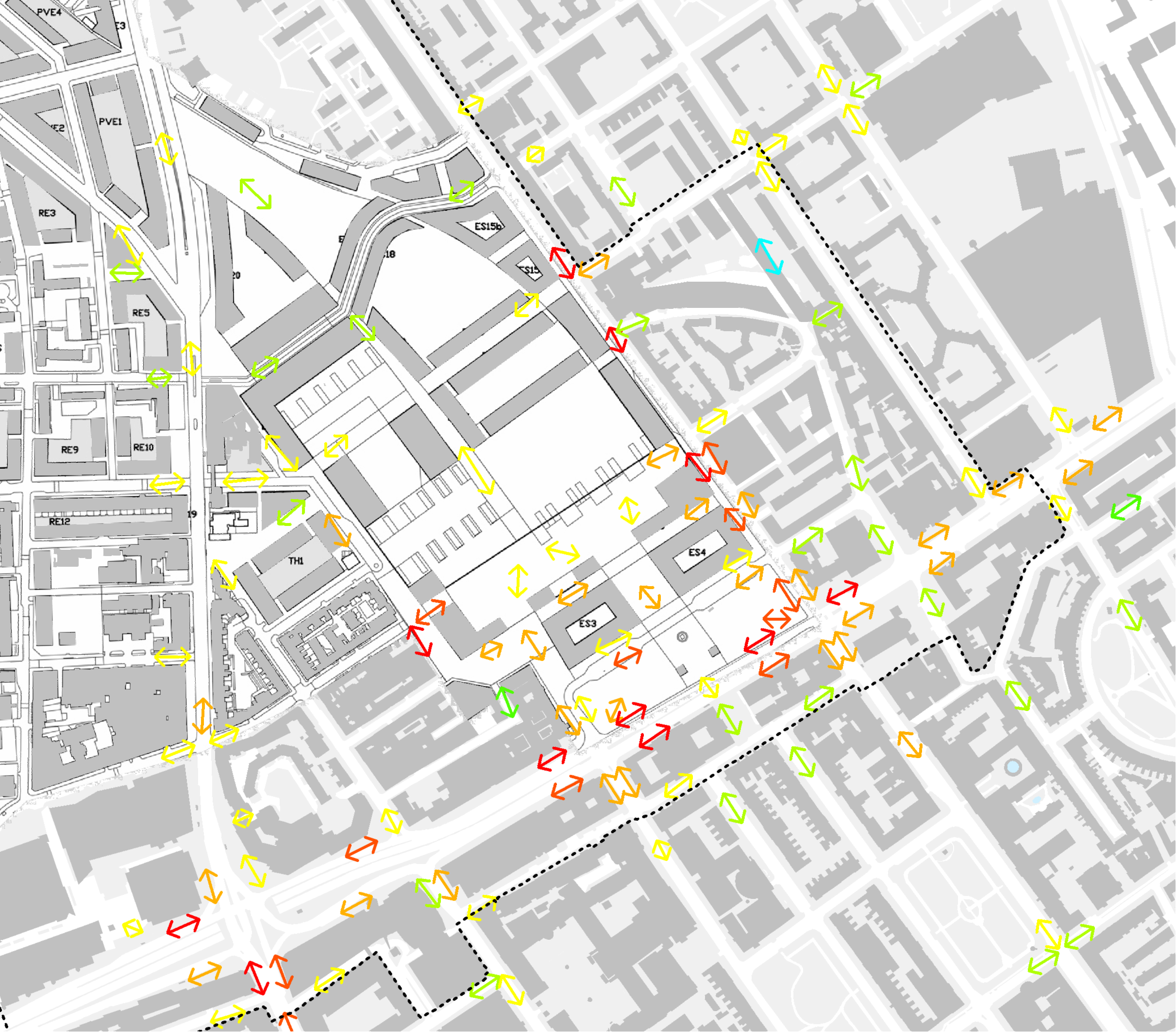
In order to study the influence transport infrastructure changes have on pedestrian and cyclist movement, both static pedestrian counts on pavement and crossings and origin and destination traces were collected, mapped and analysed.
Key findings suggest the majority of the pedestrians moves along pedestrian desire lines even without designated infrastructure such as pedestrian crossings.
Measure
To understand the linkages between urban form and pedestrian movement, urban form parameters such as spatial, land use and transport accessibility were measured and related to urban movement.
A key link was established between urban movement in the study area with the spatial layout of the road and pedestrian network, the definition and attraction of land uses and the transport infrastructure that brings people into and around Central London.
Model
Having established the evidence between urban form and urban movement, a pedestrian and cyclist movement model was constructed to forecast the impact of different HS2 scenarios on pedestrian movement levels with variations on transport infrastructure, pedestrian network and land use.
Results of the forecast model were used to assess pedestrian comfort of proposed pedestrian and cyclist infrastructure for the detail study area and to provide design recommendations for the wider study area.
Pedestrian movement model
At the centre of the pedestrian movement analysis lays the pedestrian movement model.
The creation of this model starts with exploring many potential related factors that could influence observed pedestrian movement. Through a statistical correlation process, the most significant parameters were defined and form the basis of the model.
By combining the selected parameters and correlating them with existing movement patterns the forecast model is created. By altering the parameters according to different scenarios pedestrian movement can be predicted and compared.
Inserting the predicted movement into an agent-based pedestrian simulation detailed crossing forecast can be obtained.
Cycling movement model
Besides pedestrian movement, the future cycling demand was also assessed in order to understand the localised impacts of increased cyclist movement related to the Euston Area Plan and HS2 and where improvements to cyclist infrastructure might be required in the future.
In order to find out which key features in the area around Euston Station influence existing cycling movement patterns, many different variables were considered.
Using a statistical correlation model key cycling movement indicators were identified. Spatial accessibility, the designation of cycle lanes and tracks and cycle hire stations were found to most significant factors.
These factors were correlated with existing cycling patterns in order to predict and compare the different future scenarios.
Existing but also newly proposed highly accessible routes were forecasted to have a significant increase in cycling usage. Amenities such as cycle parking, separate cycle lanes along these routes were suggested to accommodate this growth.
A model was developed to forecast the impact of different scenarios for the study area.

