London, Riots Research
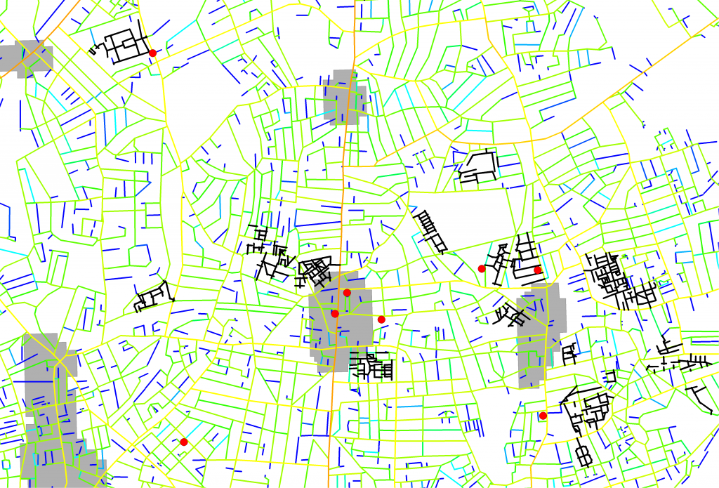
Extract of north London study area showing how well connected each street is (red indicates a space is well connected, blue indicates it is poorly connected), the location of riot incidents (red dots), defined town centres (grey areas) and the location of large post-war housing estates (black lines).
London-based consulting company Space Syntax Limited has undertaken an initial spatial analysis of the London Riots in terms of a) the location of incidents and b) the addresses of convicted rioters.
The principal aim of the study was to test a hypothesis that riot incidents occurred in places that were both near town centres and near large post-war housing estates. Space Syntax founder, Bill Hillier, has previously conjectured that the overly complex spatial layout of these housing estates has an effect on social patterns, often leading to social malaise and antisocial behaviour1.
Publicly available riot datasets were combined with established town centre locations (courtesy of CASA) and Space SyntaxTM spatial network analysis. Two study areas covering 12 town centres were defined in north and south London.
Visual analysis (A) supports the hypothesis with riot locations (red dots) being close to both town centres (grey areas) and large housing estates (black lines). This result holds up to further quantitative analysis:
In the north London study area, 84% of verified incidents took place in local centres that are within a five minute walk (400m) of housing estates. In the south London study area, this figure increases to 96%.
Local centres that were unaffected, such as Stoke Newington, are as well connected as many of the areas where incidents were recorded (see map above). However in these areas there are no large post-war housing estates in close
proximity. This is the case in 75% of the unaffected local centres within the north and south London study areas.
It has been suggested by others that there is a link between riot locations and the nearby presence of social housing. We think this link can be more accurately defined.
Hillier’s earlier work suggests that the proximity of riot activity to large post-war housing estates may not be the result of social housing in itself but the type of social housing: most post-war housing estates have been designed in such a way that they create over-complex, and as a result, under-used spaces. These spaces are populated by large groups of unsupervised children and teenagers, where peer socialisation can occur between them without the influence of adults. This pattern of activity, and the segregation of user groups, is not found in non-estate street networks. Our analysis of court records shows that almost three quarters of convicted rioters in the study areas live on large post-war housing estates.
There are a series of next steps which would help to consolidate the fi ndings of this study:
– further test the hypothesis that the spatial configuration of large post-war housing estates is a factor by using census data to study the proportions of social housing within 400m of incident locations.
– extract data from the index of multiple deprivation to develop a more detailed understanding of the relationships linking rioting activity with socio-economic circumstances and spatial configuration.
– extend the study areas to look at the whole of London, and to look at other affected UK cities.
– include the nature of different incidents and the time they took place, to understand how rioting activities and locations change.
Post-war estates are typified by having overly complex spatial layouts. This means that many spaces are under-used by everyday activity.
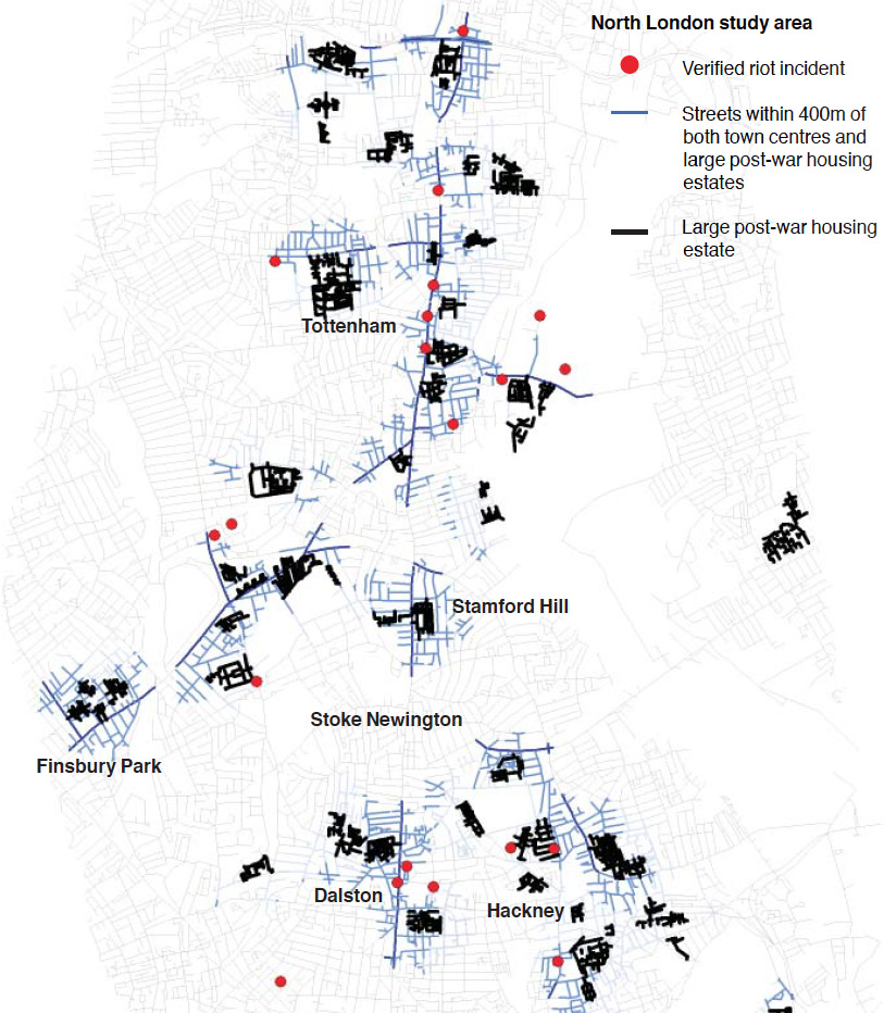
Extract from the north London study area, showing streets (blue) that are within 400m of both town centres and large post-war housing estates (black). Note that Stoke Newington, unaffected by the rioting/looting, lies outside this catchment
